Sunday, 20 February 2011

The American West Part 12: Monument Valley

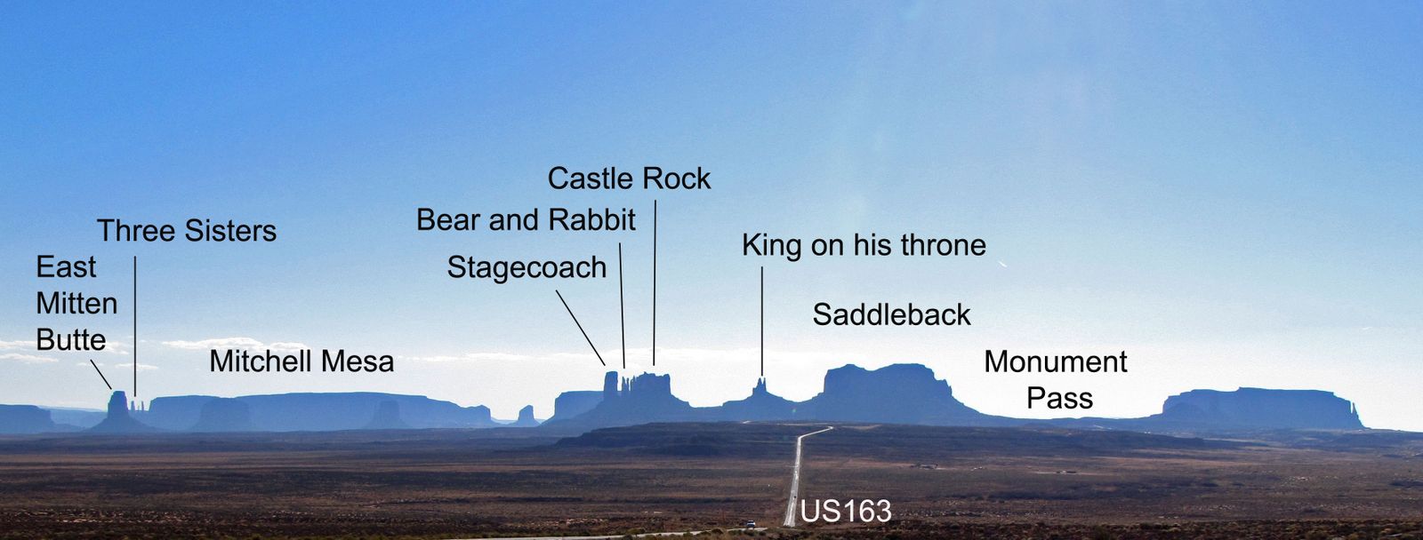
The area is part of the Colorado Plateau. The floor is largely siltstone or its sand deposited by the meandering rivers that carved the valley. The vivid red colour comes from iron oxide exposed in the weathered siltstone. The darker, blue-grey rocks in the valley get their colour from manganese oxide. Approaching from the north many of the famous landscape features reveal themselves.


West and East Mitten and Merrick Buttes at the start of the
Valley Drive.


Mitchell Mesa overlooks the Visitors Centre.


We arrived at the valley just before sunset.


Sentinel Mesa, Bear and Rabbit, King on his Throne and West Mitten Butte.


The view from John Ford’s Point at sunset.


Camel Butte with the shadows of the Three Sisters


The Three Sisters at sunset.


Where Forrest Gump stopped running.


After an overnight stop at Kayenta in Navajo country we continued south through the western edge of the Painted Desert.


As an avid reader of the Tony Hillerman series of books featuring the detectives Leaphorn and Chee I could not resist looking upon this as a scene from one of the stories.

Friday, 7 January 2011

The American West Part 11: Mesa Verde NP, Colorado

Mesa Verde, Spanish for green table, offers a spectacular look into the lives of the Ancestral Pueblo people who made it their home for over 700 years, from A.D. 600 to A.D. 1300. The park is famous for its 600 cliff dwellings.


A steep narrow winding road climbs up onto the plateau from Highway 160 in the Mancho Valley.


Once on top of the plateau the views across the Mancho Valley are very wide ranging.


It’s about 45 minutes before you see the first cliff dwellings tucked into caves and crevices in the cliff walls forming the canyon.


Many of the ruins are in or overlooking Cliff Canyon.
Mesa Verde people grew crops and hunted game on the mesa tops. The soil was fertile and except during drought, was well watered. The vegetation has changed little but there are fewer trees now.  The people cut pinyon and juniper for building materials and firewood. They reached their fields using hand and toe holds cut into the cliff face.  This is Oak Tree House, Cliff Canyon.
Cliff Palace is a larger complex . Understanding of these Ancestral Puebloans and their lives is very sketchy and archaeology seems to bring up more questions than answers.
Why such a vigorous and sophisticated civilization came to an end in the 1200's or exactly why the people moved away to settle elsewhere is still a mystery.


Spruce Tree House was one of the largest villages in Mesa Verde. It had 129 rooms and 8 kivas (enclosed ceremonial pits). About 60 to 90 people lived here at any one time.
Not all remains are to be found in the cliff face. Some sit on the top of the mesa.

Modern Pueblo Indians assure us that the Sun Temple's features mean it is a ceremonial structure. Household goods nor roof beams were found pointing to the possibility that the building was never finished.


A large well organised labour force was needed for its construction. The stones in the fine masonry walls were shaped and given a "dimpled" flat surface and were probably between 11 and 14 feet high. The thick walls were double coursed and filled with a rubble core.

Wednesday, 29 December 2010

The American West Part 10: Denver to Moab


We arrived at Denver for an overnight stay before leaving the Plains to go west across the Rockies to Moab. The "Mile High City"  looked clinically modern with its pedestrianised 16th Street Mall enclosed by high rise buildings.


From the window of the dining room on the top floor of our hotel the lights of Denver illuminated the city landscape below.


Probably the most spectacular setting for dinner on the whole trip.


Next morning we made our way west along Interstate 70 to cross the Rocky Mountains via Loveland Pass.


We paused for a leg stretch at Vail, a relatively recent ski town creation of semi-Alpine and  fake Tyrolean-style chalets awaiting the first snowfall of winter.


160 miles west of Denver we began our descent through Glenwood Canyon where we joined the upper reaches of the Colorado River.


Between Grand Junction and Crescent Junction we passed Book Cliffs.


The cliffs are largely composed of sedimentary materials. The name comes from the cliffs of Cretaceous sandstone that cap many south-facing buttes that appear similar to a shelf of books.
Arches National Park is in eastern Utah near Moab. It is known for its natural sandstone arches of which some 2000 have been preserved, including the world-famous Delicate Arch.


Forty-three arches have collapsed due to erosion since 1970.


The sandstone forms narrow ridges or fins. Small holes appear and develop into larger windows and then arches. Water from rain or snow dissolves the calcium carbonate that cements the sandstone grains together. The loose sand is washed away. The arches grow larger and eventually collapse.
As well as arches other identifiable monolithic landmarks are to be seen such as The Organ.


The Tower of Babel

The Three Gossips


There are petrified sand dunes.

A Balancing Rock

and a Parade of Elephants.
All this in one national park.


Even a Double Arch.
Before we retired for the night we even had time for a boat trip on the Colorado.


and Balancing Rock.
Tuesday, 28 December 2010

The American West Part 9: The Badlands National Park

This remarkable and strange landscape is effectively a multi-layered escarpment undergoing erosion and causing it to recede north and northwestwards. The layers of sand, silt, ash, mud and gravel have been slowly eaten away and carved into pinnacles, precipices, pyramids, knobs, cones, ridges and gorges.


In places the prairie is pock marked with the holes of the prairie dog where they congregate into township like communities.