Wednesday 29 December 2010

The American West Part 10: Denver to Moab


We arrived at Denver for an overnight stay before leaving the Plains to go west across the Rockies to Moab. The "Mile High City"  looked clinically modern with its pedestrianised 16th Street Mall enclosed by high rise buildings.


From the window of the dining room on the top floor of our hotel the lights of Denver illuminated the city landscape below.


Probably the most spectacular setting for dinner on the whole trip.


Next morning we made our way west along Interstate 70 to cross the Rocky Mountains via Loveland Pass.


We paused for a leg stretch at Vail, a relatively recent ski town creation of semi-Alpine and  fake Tyrolean-style chalets awaiting the first snowfall of winter.


160 miles west of Denver we began our descent through Glenwood Canyon where we joined the upper reaches of the Colorado River.


Between Grand Junction and Crescent Junction we passed Book Cliffs.


The cliffs are largely composed of sedimentary materials. The name comes from the cliffs of Cretaceous sandstone that cap many south-facing buttes that appear similar to a shelf of books.
Arches National Park is in eastern Utah near Moab. It is known for its natural sandstone arches of which some 2000 have been preserved, including the world-famous Delicate Arch.


Forty-three arches have collapsed due to erosion since 1970.


The sandstone forms narrow ridges or fins. Small holes appear and develop into larger windows and then arches. Water from rain or snow dissolves the calcium carbonate that cements the sandstone grains together. The loose sand is washed away. The arches grow larger and eventually collapse.
As well as arches other identifiable monolithic landmarks are to be seen such as The Organ.


The Tower of Babel

The Three Gossips


There are petrified sand dunes.

A Balancing Rock

and a Parade of Elephants.
All this in one national park.


Even a Double Arch.
Before we retired for the night we even had time for a boat trip on the Colorado.


and Balancing Rock.

Tuesday 28 December 2010

The American West Part 9: The Badlands National Park

This remarkable and strange landscape is effectively a multi-layered escarpment undergoing erosion and causing it to recede north and northwestwards. The layers of sand, silt, ash, mud and gravel have been slowly eaten away and carved into pinnacles, precipices, pyramids, knobs, cones, ridges and gorges.


In places the prairie is pock marked with the holes of the prairie dog where they congregate into township like communities.


Monday 27 December 2010

The American West Part 8: In the Black Hills of Dakota

The town of Deadwood began in the 1870s as an illegal settlement because it lay within the territory granted to Native Americans in the 1868 Treaty of Laramie. The treaty had guaranteed ownership of the Black Hills to the Lakota people.
In 1874, Colonel George Armstrong Custer led an expedition into the Hills and announced the discovery of gold at French Creek. This triggered the Black Hills Gold Rush and gave rise to the lawless town of Deadwood.


The town attained notoriety for the murder of Wild Bill Hickok by Jack McCall who was arrested after trying to hide inside Goldberg’s.


Mount Rushmore National Memorial was carved into the granite face of the mountain by Gutzon Borglum and his son Lincoln. The monument features the 60-foot heads of 4 former presidents, George Washington, Thomas Jefferson, Theodore Roosevelt and Abraham Lincoln. It is a spectacular sight standing against a bright blue sky back drop.


Work began in 1927 a stopped when funding ran out in 1941. Originally each president was to be depicted from head to waist.


It was easy to spend a long time staring at the faces because the longer that you did, the more detail you could see.


George Washington


Abraham Lincoln


A more contentious monument is the Crazy Horse Memorial commissioned by Lakota Chief, Henry Standing Bear, and to be sculpted by Korczak Ziolkowski starting in 1948.


Ziolkowski died in 1982. The entire complex including visitors centre and museum is owned by the Crazy Horse Memorial Foundation. Ziolkowski's wife Ruth and their ten children remain closely involved with the work, which has no fixed completion date. The face of Crazy Horse was completed and dedicated in 1998

Sunday 19 December 2010

The American West Part 7b: Concerning Native Americans

Battle of the Little Big Horn

(Sorry about the gaps in this posting. There is nothing missing. I do not know how to stop them occuring)
Far from any glamorised depiction of the event, the site of the clash of cultures between the Northern Plains Indians and the U.S. Army on June 25th and 26th, 1876, is a silent, sobering and emotional spot amidst an undulating, unforgiving, grassland landscape.


The 7th Cavalry, numbering about 600 men, located the Indian camp at dawn on June 25. Custer divided his regiment into 3 battalions. Benteen was ordered to scout the bluffs to the south, while Custer and Reno headed towards the Indian camp in the valley of the Little Big Horn. Reno was ordered to attack the nearest end of the camp.

25 June 1876 3.00pm
Reno’s battalion of 175 soldiers, civilian personel, Crow and Arikara scouts halt in the valley and form a thin skirmish line. Warriors rush out from the village to oppose him. After 10 minutes Lakota and Cheyenne warriors outflank Reno forcing him into the woods.


3.15 – 3.55pm

After fighting for 30 minutes Reno has no alternative but to retreat across the Little Big Horn river. Crazy Horse, Wooden Leg, Black Elk and some 600 warriors chased the soldiers across the Little Big Horn River and ride among the troopers, killing about 40 as they attempt to reach the bluff from where the picture is taken.


4.00pm

Lakota and Cheyenne casualties were few. Reno is entrenched on the hill and . Benteen manages to join him. The surrounded troops make a determined stand until the Indians withdraw the next afternoon.


Indian scouts and guides working for the U.S. Army also fell to the onslaught.


Without informing Reno or Benteen, Custer took his command along Sharpshooter Ridge (here from right to left) to attack the Indian Camp from the north.


Wooden Leg Hill was occupied by Lakota and Cheyenne during the fight on Last Stand Hill. An unknown Sioux warrior spotted by Wooden Leg was killed here while firing at soldiers positioned behind a horse barricade on the ridge behind.


Detail from an information board at Wooden Leg Hill.


Meanwhile the remains of the 7th Cavalry under Custer were attempting to defend their hopeless position on Last Stand Hill. Lakota, Cheyenne and Arapaho warriors surround  them. Custer and about 41 men shoot their horses to use as breastworks and fight until they run out of ammunition.


Eric von Schmidt's painting entitled "Here Fell Custer" is considered by historians to be the most accurate portrayal on canvas of the battle on Last Stand Hill.


Custer and several soldiers were found near the crest of the hill and others down the slope.


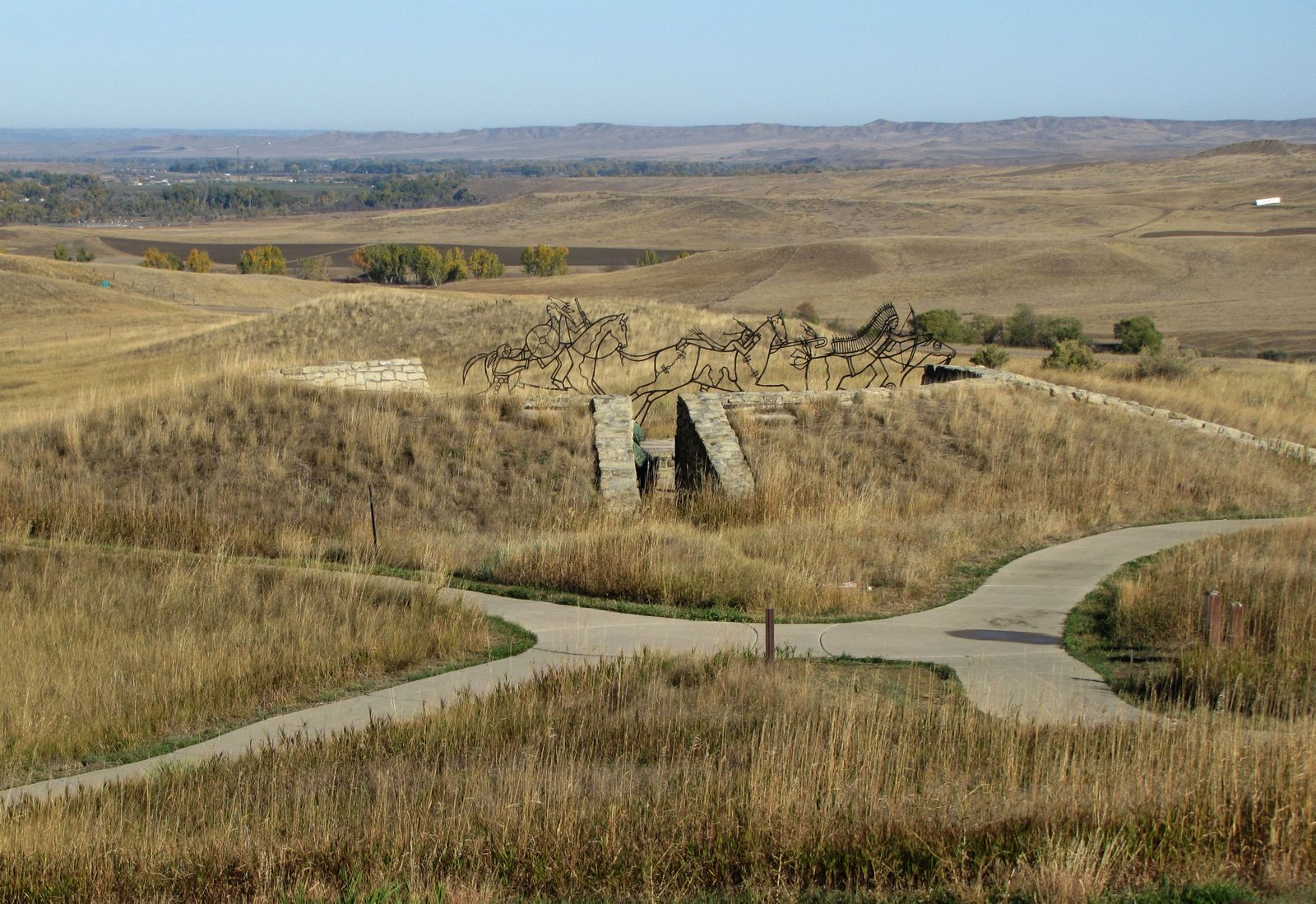
The Indian Memorial “Peace Through Unity”

At least 100 American Indian men, women, and children diedas they fought in defence of their families, land, and traditional way of life.
On December 10, 1991, President George Bush signed legislation to change the battlefield’s name from “Custer” to “Little Bighorn” Battlefield National Monument and to create the Indian Memorial. Members of the Indian tribes involved in the battle, historians, artists, and landscape architects have overseen the process. The theme “Peace Through Unity” was adopted in accordance with the advice of Elders Austin Two Moons (Northern Cheyenne) and Enos Poor bear, Sr. (Oglala Lakota).

Visitors inside the memorial see a view of the Cavalry obelisk through a “spirit gate” window. The spirit gate welcomes the Cavalry dead symbolically into the memorial’s circle.


For many tribes, a circle is sacred, and it remains open for ceremonial events. The surrounding walls carry the names of those who fell here as well as the words of some who fought in the battle.